
 Recommended On
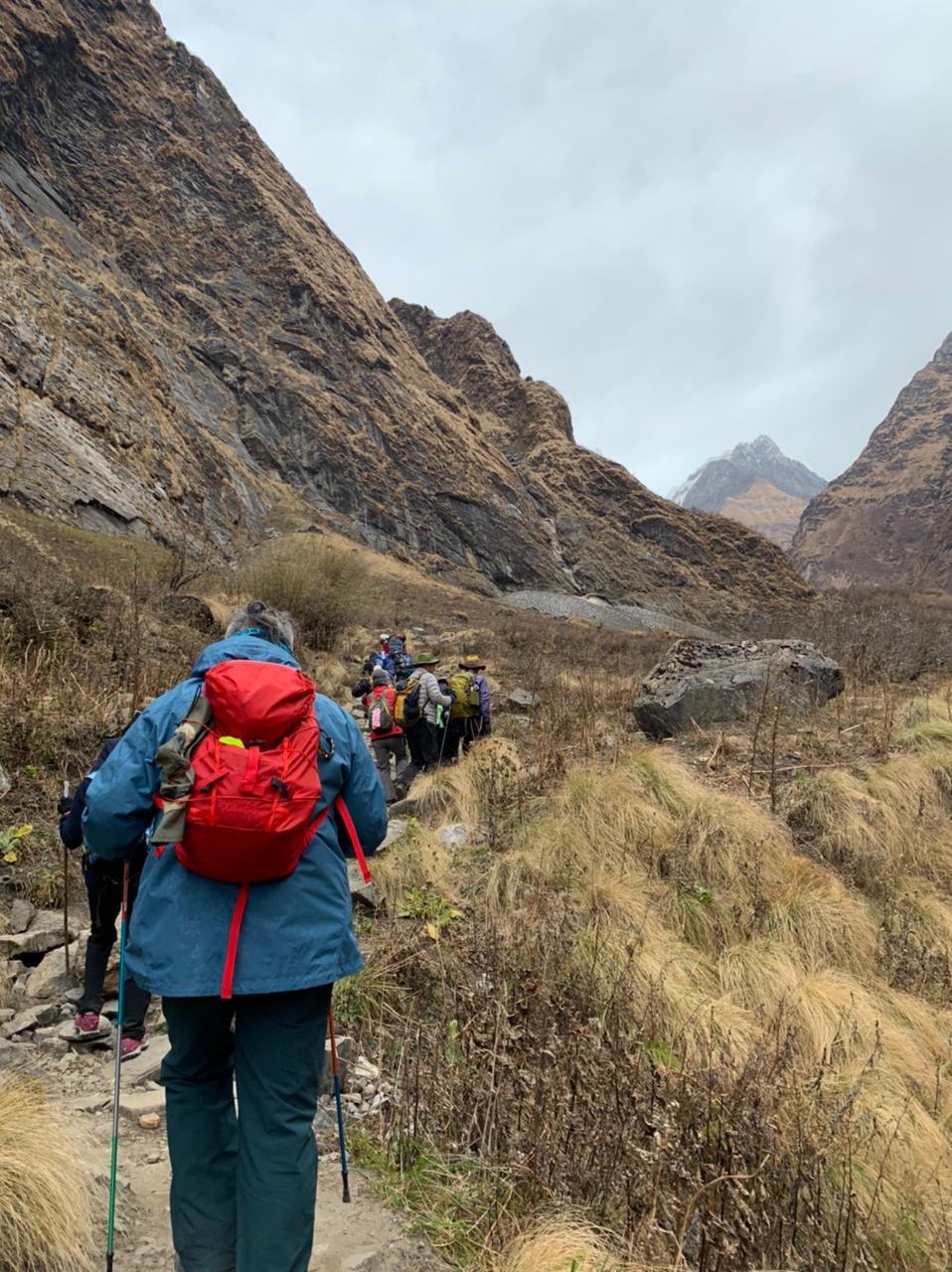
The Annapurna Circuit Trek is a 13-day route that circles the entire Annapurna massif, crossing Thorong La Pass at 5,416 meters, descending through the Mustang corridor to the sacred Muktinath Temple at 3,760 meters, and returning via the Kali Gandaki Gorge and the Poon Hill sunrise viewpoint. The route covers 160 to 230 kilometers and takes you through subtropical forest, alpine meadows, Tibetan plateau terrain, and the rain-shadow landscape north of the Annapurna massif.
World Expedition Nepal runs the 13-day Annapurna Circuit Trek at USD 1,370 per person. The package includes airport transfers, hotel accommodation in Kathmandu and Pokhara, all meals on the trail, an ACAP permit, a licensed English-speaking guide with all expenses, and strong Sherpa porters with full insurance.
Most competitors describe the Annapurna Circuit as simply "moderate." The accurate grade is moderate to challenging. Below Manang, the trek is straightforward. Above it, altitude accelerates, hours extend to 9 on the Thorong La crossing day, and temperatures at Thorong Phedi drop to -10°C before dawn in autumn. The 2014 snowstorm on Thorong La in early October killed more than 40 people. Mid-October through mid-November is the reliable autumn window, not the broadly stated "September to November."
Annapurna Circuit Trek - Trip Highlights
-
Crossing Thorung La Pass at 5,416 metres and hiking down to beautiful Jomsom and Muktinath.
-
The exploration of the World's deepest Kali Gandaki Gorge and the snow-clad Tibetan Plateau.
-
The panoramic view of Annapurna I, to IV, Machhapuchhre, Gangapurna, Manaslu, and several other peaks rising from it.
-
Witnessing the abundant cultural and rituals of Gurung and Thakali throughout the Annapurna Circuit.
-
Trekking through different climatic zones and experiencing the vivid alpine landscape of Manang and Mustang.
-
Taking a bath over 108 waterspouts at the sacred Muktinath and riding a bike in the spectacular village of Kagbeni.
-
Fantastic sightseeing at Muktinath, apple valley Jomsom, and sipping Marpha, an apple brewery made in Jomsom.
-
Fully guided trek with expert-designed itineraries from World Expedition Nepal.
Why Choose the Annapurna Circuit Trek?
The Annapurna Circuit Trek offers Nepal's most diverse trekking experience, combining the high-altitude crossing of Thorong La Pass, the dramatic Kali Gandaki Gorge, multiple climate zones, and the sacred Muktinath Temple in a single journey.
Cross Thorong La Pass at 5,416 Metres
Thorong La is the highest point on the Annapurna Circuit and the defining challenge of the entire route. The crossing gains nearly 1,000 meters from High Camp (4,925m) to the pass summit over 6 kilometers of steep rocky trail. Most trekkers depart by 4 to 5 AM to cross before the afternoon wind and cloud arrive. The descent to Muktinath drops 1,656 meters in a single day, making it the longest elevation-change day on any major Nepal trekking route.
Experience the World's Deepest Kali Gandaki Gorge
The Kali Gandaki River cuts a gorge between Dhaulagiri (8,167m) and Annapurna I (8,091m) that is deeper than any other river gorge on Earth by vertical measurement. The section from Muktinath through Kagbeni and Jomsom follows this gorge southward. Afternoon wind in the Kali Gandaki valley regularly exceeds 40 to 60 km/h, funneled by the gorge walls, which is why the trek follows an anticlockwise direction to make the Thorong La approach from the more sheltered east.
Trek Through Multiple Climate Zones
The Annapurna Circuit covers more distinct ecological zones than any other Nepal trek. Starting below 900 meters at Bhulbhule, you pass through a subtropical river valley, temperate rhododendron and pine forest, alpine meadow, Tibetan plateau terrain above the treeline, the rain-shadow desert of the Mustang corridor, and terraced farmland of the Gurung communities on the return section through Ghorepani. No other trek in Nepal crosses as many distinct climate transitions.
Visit the Sacred Muktinath Temple
Muktinath sits at 3,760 meters and is one of the holiest pilgrimage sites in Asia for both Hindus and Buddhists. The temple complex includes 108 stone waterspouts fed by spring water, an eternal flame that burns from natural gas seeping through rock, and multiple shrines visited by tens of thousands of Indian and Nepali pilgrims each year. The Muktinath visit arrives immediately after the Thorong La crossing, giving the descent day a powerful cultural destination.
Annapurna Circuit Trek Itinerary (13 Days)
Day 1: Drive from Kathmandu to Bhulbhule (845m) - 7 to 8 hours
After breakfast at your Kathmandu hotel, the drive heads northwest on the Prithvi Highway through Trishuli Bazaar and Dumre before turning north toward Besisahar. From Besisahar, a local vehicle continues the final section to Bhulbhule along the Marsyangdi River valley. The road offers the first views of the Annapurna range's eastern ridgelines as you approach the trek entry point. Register your ACAP permit at the trek entry checkpost on arrival at Bhulbhule. Take a stroll around the village in the evening and rest early for the first full trekking day ahead.
Accommodation: Teahouse lodge | Food: Breakfast, lunch, dinner
Day 2: Trek Bhulbhule to Jagat (1,300m) - 5 hours, 16 km
Depart after breakfast. The trail follows the Marsyangdi River northward through alternating forest and terraced farmland, with the river visible and audible for much of the day. The route passes through Ngadi, Bahundanda, Syange, and Jagat, with multiple suspension bridge crossings. Jagat is a neat and quiet village with good teahouses, a permit checkpoint, and the first clear views of the higher ridgelines ahead. The day is straightforward and serves as a comfortable opener to the circuit.
Accommodation: Teahouse lodge | Food: Breakfast, lunch, dinner
Day 3: Trek Jagat to Dharapani (1,860m) - 4 to 5 hours, 15 km
The trail continues north along the Marsyangdi gorge through progressively wilder terrain. The path passes through Chamje, crosses a long suspension bridge, and climbs through dense forest before reaching Tal, a wide flat plain formed by an ancient lake bed. From Tal, the trail continues through Karte and Dharapani, where the route joins the Annapurna Circuit's main river corridor. Beautiful farmland, occasional waterfalls, and local villages characterize the day. Dharapani sits at the junction with the Manaslu Circuit route and has a reliable checkpoint.
Accommodation: Teahouse lodge | Food: Breakfast, lunch, dinner
Day 4: Trek Dharapani to Chame (2,610m) - 6 hours
From Dharapani, the trail enters a pine forest as the valley narrows and steepens. The route passes through Bagarchhap, one of the first villages with distinctly Tibetan architecture and prayer flags, and continues through Danaque and Timang before reaching Chame. The Paungda Danda Rock face is visible from the upper section of the approach to Chame, a near-vertical 1,500-meter rock wall that impresses regardless of how many times guides have seen it. Chame is the administrative headquarters of Manang district, with banks, medical facilities, and a better phone signal than most of the upper trail.
Accommodation: Teahouse lodge | Food: Breakfast, lunch, dinner
Day 5: Trek Chame to Pisang (3,300m) - 5 to 6 hours
The trail continues up the Marsyangdi valley through apple orchards and dense pine forest. Two suspension bridges cross the river in quick succession after Chame. The Paungda Danda rock wall appears fully as you climb above the treeline, its sheer face rising directly from the valley floor. Annapurna II (7,937m) and Pisang Peak (6,091m) come into view from the upper section before Pisang village. Upper Pisang, reached by a short detour above the main trail, provides the best views and a monastery worth visiting. Overnight in Pisang village.
Accommodation: Teahouse lodge | Food: Breakfast, lunch, dinner
Day 6: Trek from Pisang to Manang (3,540m) - 5 to 6 hours, 17 km
Two route options connect Pisang to Manang. The lower route follows the main valley floor through Humde (with a small airport) to Manang. The upper route climbs to Ghyaru and Ngawal villages on the ridge above, offering better mountain views including Annapurna II, III, Gangapurna, and Pisang Peak, before descending to Manang. The upper route adds 1 to 1.5 hours but is the significantly better choice in clear weather. Barge Monastery, one of the largest in the Manang valley, is a short walk from the village and worth visiting in the late afternoon.
Accommodation: Teahouse lodge | Food: Breakfast, lunch, dinner
Day 7: Acclimatization Day in Manang (3,540m)
Manang is the mandatory acclimatization stop before the Thorong La crossing. Do not skip this day. The altitude jump from Pisang to Manang and then to Thorong Phedi involves significant cumulative gain. An unacclimatized Thorong La attempt is the primary cause of serious altitude incidents on the Annapurna Circuit.
The recommended acclimatization hike is to Ice Lake (Kicho Tal) at 4,620m, a 4 to 5-hour round trip from Manang that follows the climb-high-sleep-low principle. Alternatively, the hike toward Gangapurna Lake (3,900m) provides glacier views with less elevation gain. The Himalayan Rescue Association maintains an aid post in Manang staffed during trekking season, where a free altitude sickness lecture is available each afternoon and is strongly recommended for all trekkers.
Accommodation: Teahouse lodge | Food: Breakfast, lunch, dinner
Day 8: Trek Manang to Yak Kharka (4,018m) - 4 hours, 9 km
A shorter day from Manang continues the acclimatization schedule by sleeping slightly higher. The trail climbs steadily through the upper Manang valley past Tenki and Gunsang villages, through open yak and horse grazing pastures, and above the treeline into rocky alpine terrain. Yak Kharka sits in an open moorland area with views of Annapurna III, Gangapurna, and the upper Thorong La valley to the northeast. The teahouses here are basic but comfortable. Drink extra water this evening and avoid alcohol.
Accommodation: Teahouse lodge | Food: Breakfast, lunch, dinner
Day 9: Trek Yak Kharka to Thorong Phedi (4,450m) - 3 to 4 hours, 7 km
A short day with significant purpose: reaching Thorong Phedi early allows maximum rest before the 4 AM departure the following morning. The trail descends briefly from Yak Kharka before climbing steadily through increasingly barren rocky terrain to Thorong Phedi. The route is narrow in places, and the altitude is felt clearly. Arrive at Thorong Phedi by midday. Eat well, hydrate thoroughly, prepare all gear for the early morning start, and sleep by 8 PM. Do not attempt to reach High Camp (4,925m) on this same day unless you are a very experienced high-altitude trekker. The extra elevation gain can compromise your Thorong La summit attempt.
Accommodation: Teahouse lodge | Food: Breakfast, lunch, dinner
Day 10: Cross Thorong Phedi (5,416m) and Trek to Muktinath (3,760m) - 9 hours
Depart Thorong Phedi at 4 to 5 AM. The trail climbs steeply in the dark toward High Camp (4,925m) before the gradient eases slightly on the upper approach to the pass. The final section to the pass summit at 5,416 meters involves rocky switchbacks and occasional snow patches. Reach the pass by 9 to 10 AM for the best conditions and the landmark prayer flag cairn at the summit.
From the pass, the descent to Muktinath drops 1,656 meters over 9 kilometers of steeply graded rocky trail. It is long, and your knees will feel it. Trekking poles are essential. Muktinath arrives as a reward: the temple complex, the 108 waterspouts, the eternal flame, and the warm teahouses of the village are all directly ahead after crossing. Take time to visit the temple before dinner.
Accommodation: Teahouse lodge | Food: Breakfast, lunch, dinner
Day 11: Drive Muktinath to Tatopani (1,200m) - 4 hours by jeep
The day begins with a jeep drive south through Kagbeni and Jomsom, passing through the Kali Gandaki Gorge between Dhaulagiri and the Annapurna massif. Jomsom, the main town in the Mustang corridor, has an airport with flights to Pokhara (25 minutes) for those who need a faster exit. The drive continues south through Marpha, famous for its apple orchards and apple brandy, and continues to Tatopani at 1,200 meters.
Tatopani means "hot water" in Nepali. The geothermal hot springs here are a mandatory evening stop for every tired trekker. Soak in the pools for 45 minutes after dinner. Your legs will thank you significantly on the walk to Ghorepani the next morning.
Accommodation: Teahouse lodge | Food: Breakfast, lunch, dinner
Day 12: Poon Hill Sunrise Hike and Drive to Pokhara (820m)
Wake at 4 AM for the 45-minute pre-dawn climb to Poon Hill (3,210m) from Ghorepani. The Poon Hill sunrise panorama covers Dhaulagiri I (8,167m), Annapurna South (7,219m), Machhapuchhre (6,993m), and approximately 15 named peaks from a single viewpoint. After sunrise, descend to Ghorepani for breakfast. The trail then descends through rhododendron forest to Birethanti, where a vehicle waits for the 2-hour drive to Pokhara. Check in to your lakeside hotel in Pokhara for a comfortable overnight.
Accommodation: Hotel (Pokhara) | Food: Breakfast, lunch, dinner
Day 13: Drive Pokhara to Kathmandu (1,345m) - 6 to 7 hours or 30-minute flight
The return to Kathmandu by tourist bus takes 6 to 7 hours on the Prithvi Highway, with a rest stop at Muglin. A 30-minute domestic flight from Pokhara airport is the faster alternative at approximately USD 80 to 120 per person (not included in the package). The trek officially concludes on arrival in Kathmandu. A complimentary welcome or farewell dinner is arranged at a cultural Nepali restaurant for the final evening.
Accommodation: Hotel (Kathmandu) | Food: Breakfast
Annapurna Circuit Trek Difficulty
The Annapurna Circuit is moderate on the lower sections from Bhulbhule to Manang, and challenging from Manang to Thorong La and through the descent. The defining factors are altitude and the 9-hour Thorong La crossing day, not technical terrain.
Daily walking averages 5 to 6 hours below Manang. Days 9 to 10 increase to 3 to 4 hours and 9 hours, respectively. The total trek distance is 160 to 230 kilometers, depending on road sections.
AMS risk: Serious altitude illness risk begins above 3,500 meters. The most critical prevention strategy is completing the Manang acclimatization day and not skipping directly from Manang to Thorong Phedi. Thorong La at 5,416 meters has an oxygen availability of approximately 52% of sea level.
Beginner suitability: Fit beginners with no prior high-altitude experience can complete the Annapurna Circuit with the correct 13-day paced itinerary. Skipping days to reduce duration is the primary risk factor for altitude incidents.
Preparation: 4 to 6 weeks of cardiovascular training before departure. Running, cycling, and stair-climbing with a loaded pack are the most relevant exercises.
Mountains Visible on the Annapurna Circuit Trek
The mountain panorama on the Annapurna Circuit is unmatched in Nepal for variety. From different points on the route, you see:
-
Annapurna I (8,091m): Most clearly from Thorong La Pass and Poon Hill
-
Annapurna II, III, IV: Visible throughout the Manang valley section
-
Dhaulagiri I (8,167m): Dominant from Poon Hill and the Kali Gandaki gorge
-
Manaslu (8,163m): Visible from the lower eastern sections near Dharapani
-
Machhapuchhre (6,993m): The Fishtail summit is visible from Poon Hill and the Ghorepani area
-
Gangapurna (7,455m): Directly above Manang, reflected in Gangapurna Lake
-
Tilicho Peak (7,134m): Visible from the Manang valley area
Best Time for the Annapurna Circuit Trek
The best time for the Annapurna Circuit Trek is mid-October to mid-November or April to early May, when weather, visibility, and Thorong La Pass conditions are most reliable.
October 15 to November 15: The most reliable autumn window. Post-monsoon air clarity at its peak, Thorong La pass conditions are stable. Most competitor pages recommend "September to November" without noting the 2014 early-October snowstorm risk. Mid-October through mid-November is the specific window with the lowest Thorong La closure risk.
April to early May: Spring rhododendron bloom on the lower sections below 3,500 meters. The Thorong La jet stream shift north of the Annapurna massif opens stable crossing windows. Pre-monsoon afternoon cloud builds by 1 PM above 4,000 meters, so early starts matter.
December: Passable with full winter gear and flexibility for potential Thorong La snow closure. Teahouses operate, but some above Manang reduce hours.
Monsoon (June to August): The Thorong La passes can be blocked by snow, and the lower sections have landslide risk. Not recommended.
Permits Required for the Annapurna Circuit Trek
The Annapurna Circuit Trek requires an ACAP permit, while TIMS requirements vary depending on whether you trek independently or with a licensed guide, and some checkpoints may also collect an environmental fee.
Annapurna Conservation Area Permit (ACAP): NPR 3,000 (approximately USD 25) for foreign nationals. NPR 1,000 for SAARC nationals. The ACAP is the primary legal requirement for all trekking in the Annapurna region. Checked at Besisahar or Bhulbhule entry, Chame, Manang, and Jomsom checkpoints.
TIMS Card: The TIMS card situation has conflicting information across competitor sites. The official current position from Nepal Hiking Team and Nepal Tourism Board (2026): TIMS is not required for trekkers with a licensed guide on the Annapurna Circuit. Independently trekking travelers may still be asked for TIMS at some checkpoints. World Expedition Nepal handles all permit requirements before departure.
Note on the "Green Fee" (2026): A new NPR 1,000 environmental surcharge for waste management is being collected at some Annapurna checkpoints as of early 2026. Your guide handles payment at these points.
All permits are included in the World Expedition Nepal package.
Cost Breakdown
Included in the USD 1,370 Package
-
Airport pickup and drop-off in Kathmandu by private vehicle
-
3-night hotel accommodation in Kathmandu with breakfast
-
Kathmandu to Syange transfers on a local bus, Pokhara to Kathmandu on a tourist bus
-
Nayapul to Pokhara by private car
-
1-night hotel accommodation in Pokhara with breakfast
-
All meals during the trek (breakfast, lunch, dinner with tea and coffee)
-
Teahouse accommodation throughout the trek
-
ACAP permit and all government permits
-
Experienced, licensed English-speaking guide with full expenses and insurance
-
Sherpa porters with full expenses, equipment, and insurance (one porter per two members)
-
Assistant guide for groups of over 8 people
-
First aid medical kit and pulse oximeter carried by the guide
-
Welcome or farewell dinner at a Kathmandu cultural restaurant
-
All government taxes and service charges
Excluded from the Package
-
Meals in Kathmandu (lunch and dinner, except farewell dinner) and Pokhara
-
Nepal visa fee
-
Travel and medical rescue insurance (mandatory)
-
International airfare
-
Personal expenses: laundry, battery charging, phone calls, shopping
-
Alcoholic and non-alcoholic cold drinks
-
Desserts and snacks
-
Tips for guides, porters, and drivers (expected: USD 10 to 15/day for guide, USD 7 to 10/day for porter)
-
Kathmandu sightseeing entrance fees
-
Domestic flight from Pokhara to Kathmandu, if chosen instead of the bus
Annapurna Circuit Trek vs Other Popular Treks
|
Feature |
Annapurna Circuit |
Annapurna Base Camp |
Everest Base Camp |
|
Duration |
13 days |
9 days |
14 to 16 days |
|
Max altitude |
5,416m (Thorong La) |
4,230m |
5,364m |
|
Difficulty |
Moderate to challenging |
Easy to moderate |
Moderate |
|
Total permits |
USD 25 (ACAP) |
USD 37 to 42 |
USD 70 |
|
Crowd level |
Moderate |
High |
Very high |
|
Best feature |
Diverse landscapes, high pass |
Enclosed sanctuary |
World's highest mountain |
|
Distance |
160 to 230 km |
110 km |
130 km round trip |
The Annapurna Circuit covers the most terrain and landscape diversity of any Nepal trek. The ABC Trek delivers the more dramatic single destination experience at 4,230 meters. EBC requires more days and a higher permit cost but reaches a more iconic destination. For trekkers comparing all three, the Annapurna Circuit is the best choice if landscape variety and the high-pass challenge are priorities.
Why Book the Annapurna Circuit Trek with World Expedition Nepal?
World Expedition Nepal has operated the Annapurna Circuit Trek since 2017 with government-licensed guides and properly insured porter staff. Fixed departures run through spring (March to May) and autumn (September to November) with small group sizes for better guide attention and faster permit processing.
Our guides carry pulse oximeters for daily oxygen saturation monitoring above Manang. We do not compress the itinerary. The Manang acclimatization day is non-negotiable in our standard package. Every departure includes a pre-trek briefing on AMS symptoms, emergency protocols, and Thorong La conditions.
Transparent pricing: no hidden permit fees, no surprise transport charges. Everything in the includes list above is confirmed before departure.
Frequently Asked Questions
How long is the Annapurna Circuit Trek?
The World Expedition Nepal Annapurna Circuit Trek takes 13 days from Kathmandu to Kathmandu, covering 160 to 230 kilometers, depending on road sections walked versus driven.
What is the highest point of the Annapurna Circuit Trek?
Thorong La Pass at 5,416 meters (17,769 feet) is the highest point, crossed on Day 10. The descent reaches Muktinath Temple at 3,760 meters the same day, a total elevation change of 1,656 meters.
How many kilometres is the Annapurna Circuit Trek?
The full circuit covers 160 to 230 kilometers. The variation depends on how much of the lower Marsyangdi valley road section is driven versus walked. The core trekking section from Bhulbhule to Muktinath remains consistent.
Is the Annapurna Circuit Trek suitable for beginners?
Yes, with the correct-paced itinerary and fitness preparation. The 13-day itinerary with the Manang acclimatization day built in is designed for trekkers without prior high-altitude experience. Skipping acclimatization days is the primary beginner risk.
Do I need a guide for the Annapurna Circuit Trek?
The Annapurna Circuit does not legally require a guide for foreign trekkers as of 2026. However, World Expedition Nepal includes a licensed guide in all packages for route navigation, altitude monitoring, emergency coordination, and logistics management on the trail.