
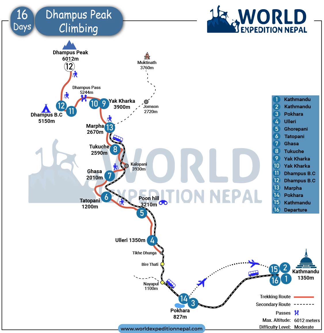
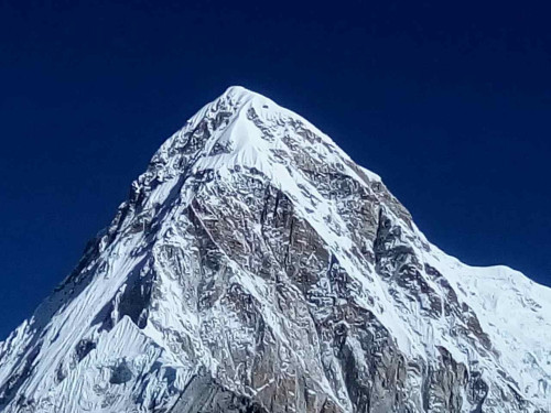
Dhampus Peak, also called Thapa Peak, stands at 6,012 meters in the Dhaulagiri region of the Nepal Himalayas, positioned on the boundary between Upper Mustang and Upper Dolpo. It is classified as a Group B trekking peak by the Nepal Mountaineering Association (NMA), making it one of the most accessible 6,000-meter summits in Nepal for climbers stepping up from high-altitude trekking. The 16-day World Expedition Nepal itinerary approaches through the Annapurna Conservation Area via Ghorepani, Poon Hill, and Tatopani, reaches the Hidden Valley via the Dhaulagiri Circuit, and summits from base camp at 5,150 meters before descending to Marpha and flying back to Pokhara.
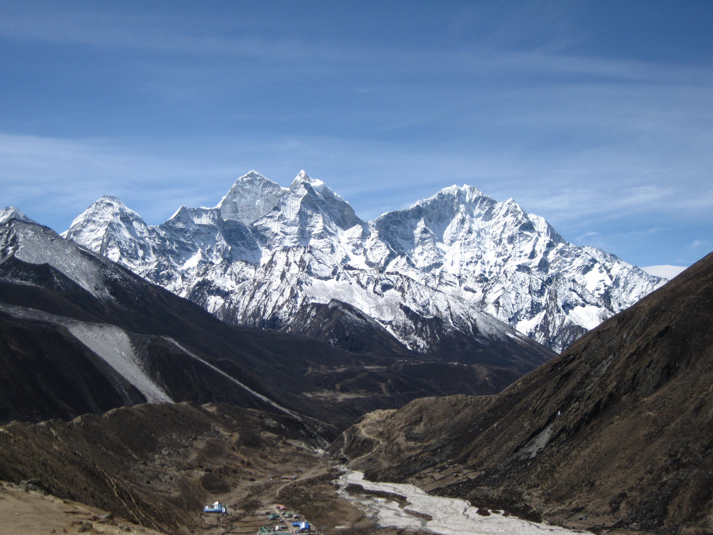
What separates Dhampus Peak from other 6,000-meter trekking peaks in Nepal is the route context. You are not climbing through a standard trekking corridor. The approach goes through the Dhaulagiri Circuit, one of Nepal's most remote and scenically varied routes, with the Kali Gandaki Gorge, French Col at 5,360 meters, and the Hidden Valley providing a consistently dramatic approach. From the summit, the panorama includes Dhaulagiri I (8,167m), Annapurna I (8,091m), Nilgiri (6,940m), Tukuche Peak (6,920m), Tilicho Peak (7,134m), Machhapuchhre (6,993m), and views into the Upper Mustang landscape to the west.
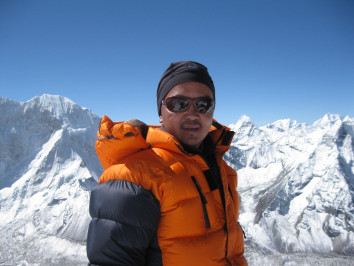
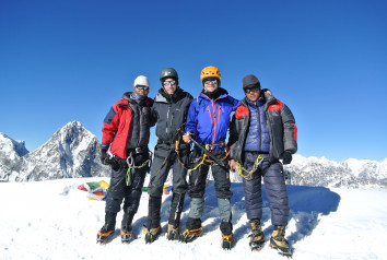
World Expedition Nepal operates this expedition with government-licensed high-altitude Sherpa guides, summit oxygen support, a Gamow bag for emergency altitude illness response, and a weather forecast service from Meteotest, Bern, Switzerland, throughout the expedition period.
Dhampus Peak sits between Mount Dhaulagiri (8,167m) to the west and the Annapurna massif to the east, in a section of Nepal rarely visited by standard trekking traffic. The peak is officially listed under the NMA's 33 permitted trekking peaks and classified as a Group B climbing peak. Its position in the Dhaulagiri Circuit means it is accessed through an entirely different trail system from the Annapurna Base Camp or Everest region routes.
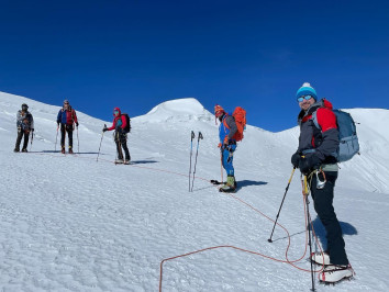
The summit at 6,012 meters involves glacier travel on the upper section, a headwall with fixed rope assistance, and a snow slope leading to the summit ridge. The technical demand is moderate. Crampons, ice axe, climbing harness, and jumar are required for the summit push from high camp at 5,600 meters. No prior 6,000-meter experience is required, but previous high-altitude trekking above 5,000 meters is strongly recommended.
Thapa Pass at 5,244 meters is crossed during the Hidden Valley approach section and is one of the highest passes on this entire expedition route.
Most competitor pages describe Dhampus Peak climbing in terms of what it shares with other trekking peaks. The more useful comparison is what it does not share.
Island Peak (6,189m) and Mera Peak (6,476m) are climbed by thousands of people annually via heavily traveled Everest region corridors. Lobuche East (6,119m) is reached along the Everest Base Camp trekking route. Dhampus Peak sits within the Dhaulagiri Circuit, where the combined foot traffic of the entire season is a fraction of any October week at Namche Bazaar. The Hidden Valley approach, the Dhaulagiri Base Camp section, and the French Col crossing are all terrain types unavailable on any other standard trekking peak itinerary in Nepal.
For climbers who want a genuine 6,000-meter summit without crowds, without a queuing system on fixed ropes, and with a return route through Marpha's apple orchards and Jomsom, Dhampus Peak is the most rewarding option in its difficulty category.
The Dhaulagiri Circuit combination also provides natural acclimatization through multiple days of high-altitude trekking before the summit attempt, which results in better summit-day performance than approaches that rush to base camp.
The route starts with a drive from Kathmandu to Pokhara, then to Tikhedhunga. The lower trail passes through Ulleri, Ghorepani, and Poon Hill (3,210m) before descending to Tatopani at 1,190 meters.
From Tatopani, the route climbs through Ghasa and Tukuche into the Mustang corridor via the Kali Gandaki valley. Above Tukuche, the trail enters the Dhaulagiri Circuit via Yak Kharka (4,930m). The Hidden Valley section is approached through French Col at 5,360 meters, requiring crampons and an ice axe. Your guide assesses snow conditions before this crossing.
Dhampus Peak Base Camp sits at 5,150 meters. Summit day starts pre-dawn to High Camp (5,600m), then the final push to 6,012 meters. The descent exits via Dhampus La Pass (5,250m) to Yak Kharka, Jomsom, and a flight back to Pokhara.
Your World Expedition Nepal representative meets you at Tribhuvan International Airport and transfers you to your 3-star hotel in Kathmandu. The rest of the day is free to recover from your flight and adjust to the city. In the evening, the team hosts a welcome dinner at a traditional Nepali restaurant where your guide briefs you on the full expedition plan, gear requirements, and permit documents needed the following morning.
The morning is spent on logistics: permit submission to the NMA, gear check, and equipment review with your climbing guide. The afternoon covers Kathmandu Valley sightseeing at Boudhanath Stupa, Pashupatinath Temple, Swayambhunath, and Kathmandu Durbar Square. These UNESCO World Heritage sites are all within 30 to 45 minutes of central Kathmandu. This day also gives your body time to fully adjust before the long drive and physical demands begin.
Departing after breakfast, the drive follows the Prithvi Highway westward along the Trishuli River valley. The road passes through Muglin and Damauli before opening into the Pokhara valley. As you approach Pokhara, the Annapurna range and Machhapuchhre come into clear view across Phewa Lake. You arrive at your lakeside hotel by mid-afternoon, leaving time to walk the Pokhara waterfront and prepare your daypack for the first trekking day.
A 1.5-hour drive from Pokhara brings you to Nayapul (1,039m), the start of the trek. The trail follows the Modi Khola river valley through Birethanti before reaching Tikhedhunga (1,540m). From Tikhedhunga, the trail climbs the famous Ulleri stone staircase, roughly 3,000 stone steps, gaining 600 meters of elevation in under 2 kilometers. It is the steepest sustained section of the lower approach. Overnight in Ulleri with the first open ridge views of the Annapurna foothills.
Leaving Ulleri, the trail continues uphill through mixed rhododendron and oak forest. The tree cover provides shade on a sustained but gradual climb. Small settlements appear along the way, and the first clear views of the Dhaulagiri massif open as the trail reaches the ridge above 2,500 meters. Ghorepani is a well-developed trekking village with good teahouse options. Overnight, here sets up the predawn Poon Hill departure the following morning.
Wake up at 4:30 AM for the 45-minute ascent to Poon Hill (3,210m). At sunrise, the panorama stretches across Dhaulagiri I (8,167m) on the west to Annapurna South and Machhapuchhre on the east, with roughly 15 named peaks visible from the viewpoint. Return to Ghorepani for breakfast, then descend steeply through Banthanti and Tikhedhunga to Tatopani at 1,190 meters. Tatopani has natural hot springs fed by geothermal activity along the Kali Gandaki fault, which most trekkers use for an hour of leg recovery in the evening.
The trail north of Tatopani follows the Kali Gandaki River as the valley narrows into a deep gorge. You pass through Dana, Rupse Chahara, and Kopchepani, observing Gurung and Thakali village architecture along the river terraces. The Rupse Waterfall, dropping off a high cliff directly beside the trail, is one of the most dramatic trail-side features on this route. The forest transitions to pine, and the surroundings become drier as you climb toward Ghasa, which marks the cultural shift from Gurung to Thakali territory.
From Ghasa, the trail continues through the upper Kali Gandaki valley with increasingly open views of the Nilgiri massif above. You pass through the village of Marpha, a tightly built whitewashed Thakali village famous for its apple orchards. Marpha produces apple brandy, dried apples, and apple jam sold directly from local shops. The upper Dhaulagiri south face becomes visible from the trail above Marpha. Tukuche has a notable old monastery worth visiting before dinner. Overnight at Tukuche.
This is the longest and most demanding day of the trekking approach, climbing over 2,300 meters above Tukuche into the high plateau zone above 4,000 meters. Vegetation reduces to sparse alpine scrub as you gain altitude. The trail passes through Larjung before entering the upper grazing pastures where yak herders camp in summer. By the time you reach Yak Kharka, Nilgiri (6,940m), Annapurna I (8,091m), and Dhaulagiri I (8,167m) are all clearly visible in the surrounding skyline. Overnight at a basic lodge. This is the last teahouse accommodation before base camp.
A full rest day at Yak Kharka is mandatory before the push into the Hidden Valley. In the morning, your guide leads a 1 to 2-hour acclimatization hike to approximately 5,200 to 5,300 meters and back, allowing your body to adapt to altitude without sleeping high. This walk also serves as a practice session for crampon fitting and basic ice axe handling before the technical sections ahead. Pulse oximeter readings are taken morning and evening. Altitude above 4,500 meters is where AMS risk rises sharply, and this day exists specifically to lower that risk on the days ahead.
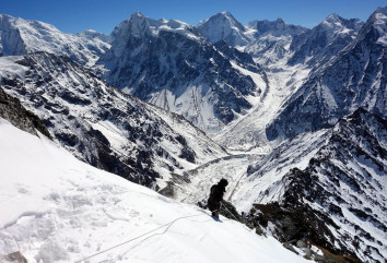
Departing Yak Kharka, the trail enters the Hidden Valley through the Dhaulagiri Circuit approach. The terrain shifts to moraine, scree, and snowfield sections that require careful footing. Your Sherpa team sets the pace for a controlled ascent. The route passes the Dhaulagiri Base Camp area and climbs through the French Col approach before reaching the designated Dhampus Peak Base Camp at 5,150 meters. Tent accommodation is set up by the climbing support team in advance. The base camp sits in a sheltered glacial bowl with direct views of the summit ridge above.
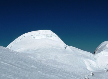
Departure from base camp begins at 3 to 4 AM. The pre-dawn start is essential to reach the headwall before the wind increases and snow softens on the upper slopes. The first section climbs moderate glacier terrain to High Camp at 5,600 meters, where a brief rest and energy refuel take place. The headwall above High Camp is the technical crux: a 50 to 60-degree ice and snow face where fixed ropes installed by your Sherpa team are ascended with a jumar. Above the headwall, a snow ridge leads to the summit at 6,012 meters. Summit time is typically 8 to 10 AM. Views from the top span Dhaulagiri I, Annapurna I, Nilgiri, Tukuche Peak, Tilicho Peak, Machhapuchhre, and across Upper Mustang to the west. After photographs and summit time, the descent follows the same fixed rope system back to High Camp and then to base camp for overnight.
The descent day drops over 2,400 meters from base camp to Marpha via Dhampus La Pass (5,250m). The pass crossing requires crampons on the base camp side in most seasons. Below the pass, the terrain transitions from alpine moraine to open pasture and then into the familiar Mustang valley landscape. The rapid altitude loss delivers immediate physical recovery compared to the high camp days. Marpha, with its apple orchards and warm teahouses, is a welcome arrival after summit day. Overnight in Marpha.
Board a private vehicle or jeep from Marpha for the drive south through the Kali Gandaki gorge. The road passes through Jomsom, Tukuche, Ghasa, and the lower valley before joining the highway to Pokhara. The drive through the world's deepest river gorge, flanked by Annapurna and Dhaulagiri, is one of the most dramatic road journeys in Nepal. Arrive in Pokhara by afternoon for a well-earned rest at a lakeside hotel.
After a relaxed breakfast, transfer to Pokhara Airport for the afternoon domestic flight to Kathmandu. The 25-minute flight crosses the Himalayan foothills with clear views of the Annapurna range on departure. Transfer to your Kathmandu hotel on arrival. The evening is free for final shopping in Thamel, a team dinner, or rest before departure.
Your World Expedition Nepal representative transfers you to Tribhuvan International Airport 3 hours before your scheduled international flight. Your climbing certificate, issued by the NMA on successful summit completion, is provided before departure.
Cost Includes
Dhampus Peak, also known as Thapa Peak, rises to 6,012 meters (19,724 feet) in Nepal’s Dhaulagiri region. It is a Nepal Mountaineering Association (NMA) Group B trekking peak located between Upper Mustang and Upper Dolpo.
Dhampus Peak climbing is considered moderate to challenging. Climbers use crampons, fixed ropes, and a jumar during the summit push. Strong fitness, high-altitude trekking experience, and the ability to walk 7 to 8 hours daily are recommended.
Yes, Dhampus Peak is suitable for beginners with prior trekking experience above 4,000 meters. Basic mountaineering skills, including crampon and ice axe use, are taught by guides, though previous high-altitude experience is strongly advised.
The standard Dhampus Peak Climbing itinerary takes 16 days from Kathmandu to Kathmandu. This includes arrival, trek approach, acclimatization, summit attempt, descent, and return travel to the capital.
Dhampus Peak requires an NMA climbing permit and an Annapurna Conservation Area Permit (ACAP). Permit fees vary by season, and licensed operators typically arrange all required permits before the expedition begins.
To climb Dhampus Peak, you will need to obtain the following permits:
Trekking Information Management System (TIMS) Card: The TIMS card is necessary for trekking in the Annapurna region, including climbing Dhampus Peak. It is a registration card that helps keep track of trekkers and ensures their safety.
It's important to note that permit requirements and fees can change over time, so it's recommended to check with the local authorities or consult with a reputable trekking agency for the most up-to-date information regarding permits and their costs.
The best months for Dhampus Peak climbing are generally considered to be during the pre-monsoon (spring) season and post-monsoon (autumn) season in Nepal. In the pre-monsoon season, which spans from March to May, climbers can expect clear skies, mild temperatures, and excellent visibility. The rhododendron forests along the trekking route are in full bloom, creating a vibrant and picturesque environment. The post-monsoon season, from September to November, offers stable weather conditions, clear mountain views, and comfortable temperatures. This is a popular time for trekking and climbing in Nepal, including Dhampus Peak, as the monsoon rains have subsided, leaving the trails lush and the skies crystal clear. However, it's important to note that weather patterns can be unpredictable, and it's always advisable to check the local forecasts and consult with experienced guides or trekking agencies for the most suitable timing for your Dhampus Peak climbing expedition.
Dhampus Peak is rated moderate to adventurous. It is a step above standard high-altitude trekking but does not require the prior climbing certification or technical skills needed for peaks like Ama Dablam or the Everest massif technical routes.
The summit day involves three distinct sections that determine the actual difficulty:
Lower glacier approach: Crampons required. Moderate-angle snow walking on consolidated slopes. Most trekkers with prior crampon use on high-altitude treks manage this section without significant difficulty.
Headwall section: Fixed ropes are installed by the World Expedition Nepal Sherpa team before the summit attempt. Jumar ascending technique is used. This is the most physically demanding section, requiring upper body strength and stamina at 5,800 to 5,900 meters, where oxygen availability is approximately 48% of sea level.
Summit ridge: Snow and mixed terrain at 6,012 meters. Wind exposure increases significantly. This section is typically 30 to 45 minutes from the headwall top to the summit marker.
The approach route through the Dhaulagiri Circuit also requires stamina across consecutive 7 to 8-hour walking days at progressively higher altitudes. French Col at 5,360 meters, crossed before base camp, is itself higher than most trekking peaks' maximum altitude.
Physical fitness requirement: The World Expedition Nepal team recommends prior trekking experience above 4,000 meters and at least 2 to 3 weeks of consistent cardiovascular training (running, cycling, or stair climbing) in the 6 to 8 weeks before departure.
Yes, with the correct preparation. Dhampus Peak is specifically designed as a first 6,000-meter summit for climbers transitioning from high-altitude trekking. The World Expedition Nepal Sherpa guides teach crampon use, ice axe technique, and fixed rope ascending during the approach days and at base camp before the summit attempt.
Trekkers who have completed the Annapurna Circuit, Everest Base Camp, or Manaslu Circuit without AMS issues are physically and physiologically suited for Dhampus Peak with proper preparation. No prior technical climbing certification is required.
What disqualifies a beginner: no previous trekking above 3,500 meters, a history of HAPE or HACE, or cardiovascular conditions that have not been cleared by a doctor for high-altitude exertion.
The Dhampus Peak itinerary is structured with two mandatory acclimatization points: Yak Kharka (4,930m) on Day 10 and base camp (5,150m) before the summit attempt on Day 12. Both are consistent with the standard climb-high-sleep-low acclimatization principle.
AMS risk zones on this route:
Yak Kharka (4,930m): The jump from Tukuche to Yak Kharka gains approximately 2,340 meters over two trekking days. This is the highest single-stage elevation gain on the route and the most common point for early AMS symptoms.
French Col (5,360m): High exertion crossing at altitude. Trekkers who rushed the Yak Kharka acclimatization feel this crossing acutely.
High Camp (5,600m) and summit (6,012m): Above 5,500 meters, AMS risk shifts toward HAPE and HACE territory. World Expedition Nepal guides monitor SpO2 readings with a pulse oximeter at every high camp.
Emergency protocols: World Expedition Nepal carries a Gamow bag (portable hyperbaric chamber) for emergency altitude illness treatment at base camp. Satellite phone communication is available throughout the expedition for helicopter evacuation coordination. The helicopter landing zone nearest to base camp is at Yak Kharka.
Spring (March to May): The primary climbing season. April is the optimal month: stable morning weather windows, warmer overnight temperatures at base camp compared to autumn, and rhododendron bloom on the lower trail sections below 4,000 meters. The summit push in April typically benefits from the pre-monsoon jet stream shift that also opens Everest's climbing window.
Autumn (September to November): The second primary season. Post-monsoon air clarity delivers the best summit panoramas of the year. October is the most reliable month for Kali Gandaki valley conditions and Hidden Valley weather stability. November remains good but colder at base camp, with overnight temperatures dropping to -15°C to -20°C at 5,150 meters.
Monsoon and winter: Not recommended. Monsoon (June to August) brings landslide risk on the lower trail sections and unstable summit conditions. Winter (December to February) produces snowfall on the French Col crossing and summit ridge that significantly increases technical difficulty beyond the moderate grade.
From Dhampus Peak at 6,012 meters, the 360-degree panorama covers approximately 30 named peaks. The most prominent views:
8,000-meter peaks: Dhaulagiri I (8,167m) directly to the west, Annapurna I (8,091m) to the southeast.
7,000-meter peaks: Tukuche Peak (6,920m), Nilgiri (6,940m), Tilicho Peak (7,134m), Puth Hiunchuli (7,246m).
6,000-meter peaks and landscapes: Machhapuchhre (6,993m) to the south, Lamjung Himal, Hiunchuli (6,441m), and the Hidden Valley terrain below with Thapa Pass visible to the northeast.
Upper Mustang's Tibetan plateau landscape is visible to the west. Partial views into Upper Dolpo terrain are possible on clear days from the summit ridge.
World Expedition Nepal's Dhampus Peak package price is USD 3,500 per person based on a group of 2 or more. This covers the full 16-day itinerary from Kathmandu to Kathmandu.
What is included:
|
Item |
Detail |
|
Hotel accommodation |
3-star in Kathmandu and Pokhara |
|
Teahouse accommodation |
All nights on the trekking route |
|
Tent accommodation |
Base camp and high camp |
|
All meals during the expedition |
Breakfast, lunch, and dinner throughout |
|
NMA climbing permit (Dhampus Peak) |
Included |
|
ACAP permit |
Included |
|
Government liaison officer |
With full equipment, salary, and insurance |
|
High-altitude Sherpa guide |
Government licensed, NMA certified |
|
Summit oxygen |
5 cylinders (4 litres) per member |
|
Oxygen mask and regulator set |
Per member and Sherpa |
|
Gamow bag |
Emergency hyperbaric treatment |
|
Walkie-talkie and satellite phone |
Base camp to mountain communication |
|
Swiss weather forecast |
Meteotest, Bern, daily during expedition |
|
Porter support |
70 kg personal baggage per member |
|
Airport transfers |
Kathmandu both ways |
|
Government taxes |
All official charges |
|
Garbage deposit fee |
NMA mandatory, refundable on exit |
|
Climbing certificate |
Issued on successful summit |
What is excluded:
Nepal visa fee
International airfare
Lunch and dinner in Kathmandu and Pokhara
Personal expenses (laundry, cold drinks, phone calls, battery charging)
Alcoholic beverages
Tips for guides, Sherpas, porters, and drivers
Travel and helicopter rescue insurance (mandatory, arranged independently)
Extra activities not listed in the itinerary
Kathmandu sightseeing entrance fees
Dhampus Peak is classified under NMA Group B trekking peaks. The permit structure is effective from September 1, 2025:
|
Permit |
Cost |
|
NMA climbing permit (spring/autumn) |
USD 70 per person |
|
NMA climbing permit (winter/summer) |
USD 35 per person |
|
Annapurna Conservation Area Permit (ACAP) |
NPR 3,000 (approx. USD 22 to 25) |
|
Government liaison officer |
Mandatory (included in package) |
|
Garbage deposit (refundable) |
USD 500 per team |
All permits are processed by World Expedition Nepal through official NMA and Department of Tourism channels before departure. Your original passport is required at each checkpoint on the route.
Travel insurance with helicopter rescue coverage to at least 6,000 meters altitude is mandatory for the Dhampus Peak expedition. World Expedition Nepal requires a copy of your policy before the trek commences.
Your policy must cover: helicopter evacuation at or above 6,000 meters, emergency hospitalization for altitude illness, and medical treatment costs. Standard travel insurance without a specific high-altitude mountaineering clause will not cover a rescue from base camp or summit altitude.
Recommended minimum coverage: USD 100,000 for rescue and medical combined. Confirm the altitude ceiling of your policy explicitly with your insurer before purchasing.
|
Feature |
Dhampus Peak |
Island Peak |
Mera Peak |
|
Altitude |
6,012m |
6,189m |
6,476m |
|
Region |
Dhaulagiri / Annapurna |
Everest |
Khumbu |
|
Route context |
Dhaulagiri Circuit |
Everest Base Camp |
Hinku Valley |
|
Crowd level |
Very low |
Moderate to high |
Moderate |
|
Summit technical demand |
Moderate (fixed rope headwall) |
Moderate (60-degree headwall) |
Low to moderate |
|
Approach highlights |
Hidden Valley, French Col, Poon Hill |
Chhukung, EBC |
Zatrwa La pass |
|
Panorama from the summit |
Dhaulagiri, Annapurna I, Nilgiri, Mustang |
Everest, Lhotse, Makalu |
5 of the world's 14 highest peaks |
|
Duration |
16 days |
18 to 22 days with EBC |
18 to 20 days |
Dhampus Peak is the strongest choice for climbers who want a first 6,000-meter summit on a route that is genuinely off the beaten path. Island Peak delivers a higher summit with a more dramatic technical headwall. Mera Peak offers the highest accessible summit view in Nepal's trekking peak category. Dhampus Peak delivers the most distinctive overall expedition experience of the three.
World Expedition Nepal has operated peak climbing expeditions since 2017, licensed under the Nepal Government and registered with the Trekking Agencies' Association of Nepal. Our Dhampus Peak expedition team includes NMA-certified high-altitude Sherpa guides with mountain medicine and first aid training.
We carry summit oxygen (5 cylinders per member), a Gamow bag at base camp, satellite phone communication, and a daily Swiss weather forecast throughout the expedition. Our guide-to-client ratio on Dhampus Peak does not exceed 1 guide per 4 climbers.
We run small groups of 2 to 16 members with private expedition options available. All logistics from Kathmandu airport pickup to departure transfer are managed end-to-end. Contact us to confirm 2026 spring and autumn availability and to receive a detailed cost breakdown for your group size.
Enjoy the popular trekking and tour packages in Nepal Himalayas. 2026.


-1.JPG)


© 2011 - 2026 All rights reserved. World Expedition Nepal Developed By : Xenatech Nepal
 Recommended On
 Trip Map
 6000m Peak Climbing , Nepal
  29 Days
  US$3400